Estimating Wildfire Probability
/Although wildland fires are a natural part of forest ecosystems, they can interefere with the planning of land-management activities and may have an array of anthropogenic factors. The article, Spatial variability in wildfire probability across the western United States from the International Journal of Wildland Fire, uses fire obsertvations to produce detailed estimates of wildfire probability, of both natural and anthropogenic factors. The International Journal of Wildland Fire publishes papers that advance basic and applied research concerning wildland fire. The Journal wishes to attract papers on a broad range of wildland fire issues that may include subjects beyond the range of papers published in recent issues. The Journal has an international perspective, since wildland fire plays a major social, economic and ecological role around the globe. The authors of the article, Spatial variability in wildfire probability across the western United States, include Marc-Andre Parisien, Susan Snetsinger, Jonathan A. Greenberg, Cara R. Nelson, Tania Schoennagel, Solomon Z. Dobrowski and Max Moritz.
Here is the article's abstract, along with figures and their descriptions:
'Despite growing knowledge of fire-environment linkages in the western USA, obtaining reliable estimates of relative wildfire likelihood remains a work in progress. The purpose of this study is to use updated fire observations during a 25-year period and a wide array of environmental variables in a statistical framework to produce high-resolution estimates of wildfire probability. Using the MaxEnt modeling technique, point-source fire observations that were sampled from area burned during the 1984-2008 time period were related to explanatory variables representing ignitions, flammable vegetation (i.e. fuels), climate and topography. Model results were used to produce spatially explicit predictions of wildfire probability. To assess the effect of humans on the spatial patterns of wildfire likelihood, we built an alternative model that excluded all variables having a strong anthropogenic imprint. Results showed that wildfire probability in the western USA is far from uniform, with different areas responding to different environmental drivers. The effect of anthropogenic factors on wildfire probability varied by region but, on the whole, humans appear to inhibit fire activity in the western USA. Our results not only provide what appear to be robust predictions of wildfire likelihood, but also enhance understanding of long-term controls on wildfire activity. In addition, our wildfire probability maps provide better information for strategic planning of land-management activities, especially where fire regime knowledge is sparse.'

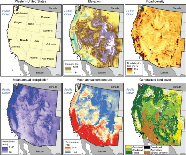
Figure 1. The study area showing the 11 western USA states, elevation, road density (computed using a 1000-hacircular window), mean annual precipitation, mean annual temperature and land cover that was generalized from the National Gap Analysis.

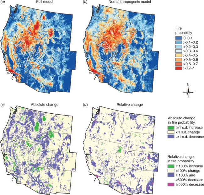
Figure 2. Mean predicted wildfire probability (based on 25 model replicates) for the Full model (a); the Non-anthropogenic model (b); the absolute change (c); and the relative change (d) from the Full model to the Non-anthropogenic model, whereby green indicates an increase and blue represents a decrease in wildfire probability as a result of human-influenced variables.
To view the entire article, please visit the website:
http://www.publish.csiro.au/paper/WF11044


